Planning
and Regulations Committee Meeting Agenda 10
April 2018

CONTENTS
1 AUTHORITY FOR PLAN................................................................................................... 4
2 DISTRIBUTION OF PLAN................................................................................................. 4
3 INTRODUCTION............................................................................................................ 5
4 OBJECTIVE.................................................................................................................... 5
5 REDUCTION.................................................................................................................. 6
5.1 Hazards and Risks................................................................................................. 6
5.1.1 Earthquake....................................................................................................................... 6
5.1.2 Lake Tsunami................................................................................................................... 6
5.1.3 Avalanche......................................................................................................................... 6
5.1.4 Flooding........................................................................................................................... 7
5.1.5 High Winds...................................................................................................................... 7
5.1.6 Landslide and Debris flow.............................................................................................. 7
5.1.7 Medical Pandemic........................................................................................................... 7
5.1.8 Road access...................................................................................................................... 8
5.1.9 Snow Storms................................................................................................................... 8
5.1.10 Wild fire............................................................................................................................ 8
6 READINESS................................................................................................................... 8
6.1 Community Coordinator:...................................................................................... 9
6.2 Incident Command Point (ICP):.............................................................................. 9
6.3 Support Agencies............................................................................................... 10
6.3.1 Police.............................................................................................................................. 10
6.3.2 Fire and Emergency New Zealand (FENZ)................................................................... 10
6.3.3 St John Ambulance....................................................................................................... 10
6.3.4 Department of Conservation (DOC)............................................................................ 10
6.3.5 Ministry of Social Development.................................................................................. 10
7 RESPONSE................................................................................................................... 11
7.1 Warnings........................................................................................................... 11
7.1.1 General........................................................................................................................... 11
7.1.2 Inward............................................................................................................................ 11
7.1.3 Outward......................................................................................................................... 11
7.2 Alpine Huts........................................................................................................ 12
7.3 Walking Tracks................................................................................................... 12
7.4 Alps 2 Ocean...................................................................................................... 12
7.5 White Horse Hill Campground............................................................................. 12
7.6 Glentanner Holiday Park..................................................................................... 12
7.7 Evacuation Procedures....................................................................................... 12
7.8 Welfare............................................................................................................. 13
8 RECOVERY.................................................................................................................. 14
9 MEDIA LIAISON........................................................................................................... 14
10 FINANCIAL.................................................................................................................. 15
10.1 Expenditure during declared events..................................................................... 15
11 ROAD CLOSURE........................................................................................................... 16
11.1 State Highway.................................................................................................... 16
11.2 Village Roads..................................................................................................... 16
12 APPENDIX A – DELEGATIONS........................................................................................ 17
13 APPENDIX B – CDEM ORGANISATIONAL
STRUCTURE...................................................... 19
14 APPENDIX C – PRE-DECLARATION CHECK
LIST................................................................ 20
15 APPENDIX D – CONTACT LIST........................................................................................ 21
16 APPENDIX E – COMMUNICATION PLAN......................................................................... 22
17 APPENDIX F – TOPOGRAPHIC MAP OF
AORAKI/MOUNT COOK......................................... 23
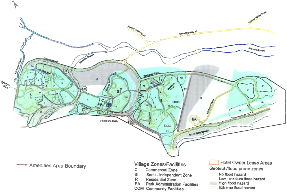
18 APPENDIX G – AORAKI/MOUNT COOK
VILLAGE FLOOD INUNDATION MAP...................... 24
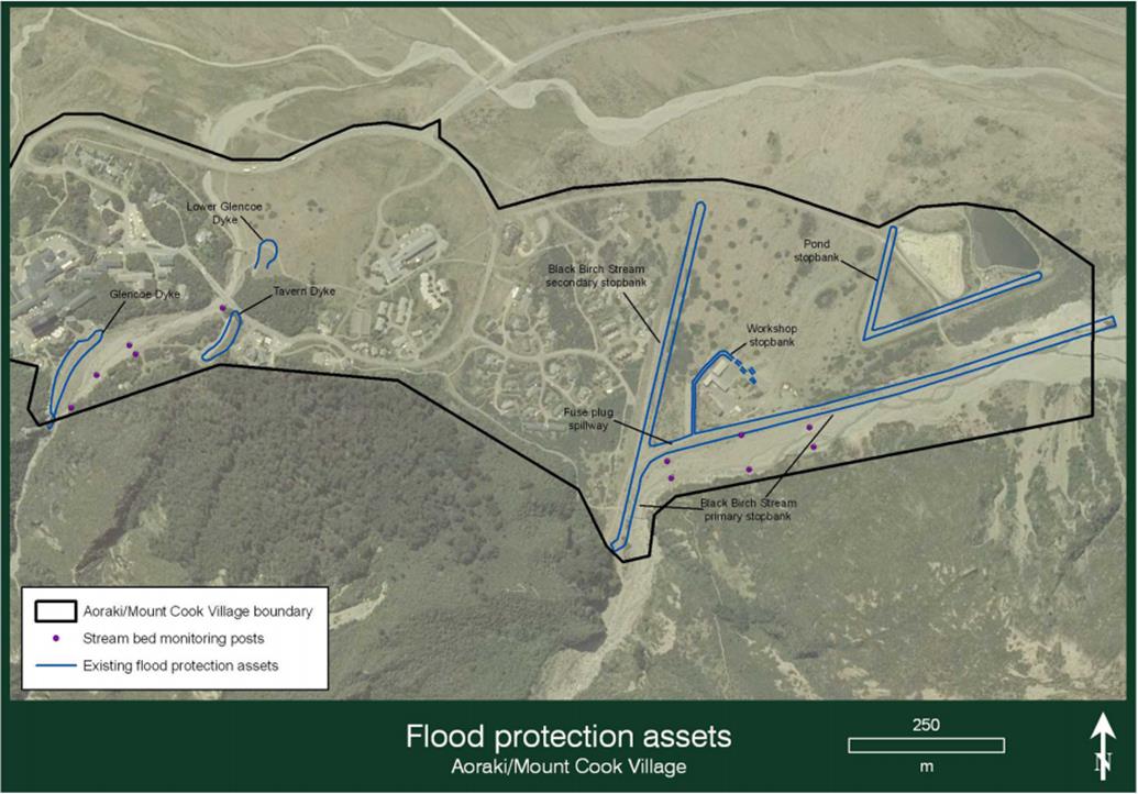
19 APPENDIX H – AORAKI/MOUNT COOK VILLAGE
FLOOD PROTECTION ASSETS................... 25
20 APPENDIX I – TOPOGRAPHIC MAP OF
GLENTANNER....................................................... 27
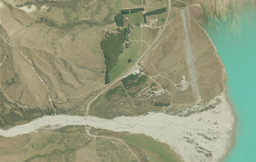
21 APPENDIX J – GLENTANNER AERIAL MAP....................................................................... 28
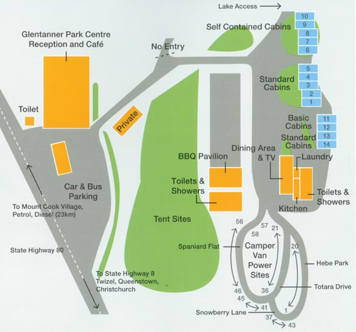
22 APPENDIX K – LAYOUT MAP OF GLENTANNER................................................................ 29
1 AUTHORITY FOR PLAN
This Plan is operational in nature and shall be
maintained by the Mackenzie District Council Civil Defence Emergency Management
Officer (EMO). Amendments and updates may be made by the EMO following
consultation with the Group Manager Projects & Administration, Mackenzie
District Council, and any relevant stakeholders that may be impacted by the
change.
This Plan was endorsed by the Planning and Regulations
Committee of the Mackenzie District Council on 10 April 2018.
This Plan will be fully reviewed at not less than two
yearly intervals. The next review will be on or before April 2020.
2 DISTRIBUTION OF PLAN
A copy of the Aoraki/Mount Cook Village &
Glentanner Area Emergency Response Plan (the Plan) shall be held by each of the
following:
1. Mackenzie
District Council
2. Canterbury
Regional Emergency Management Office
3. Department
of Conservation, Aoraki/Mt Cook
4. Community
Coordinator
5. Deputy
Community Coordinator
6. Glentanner
Station
7. Glentanner
Holiday Park
8. New
Zealand Police, Twizel
9. New
Zealand Police, Lake Tekapo
10. Emergency
Services Building, Aoraki/Mt Cook
11. The
Helicopter Line, Glentanner
Park
The contact list in Appendix D is confidential
and is to be used for emergency management purposes only. It is not to be
distributed to any parties other than those listed above.
3
INTRODUCTION
The Aoraki/Mount Cook village is located in the
National Park and is resourced and administered by the Department of
Conservation (DOC), however the responsibilities regarding Civil Defence and
Emergency Management (CDEM) rest with the Mackenzie District Council (MDC).
The Aoraki/Mount Cook National Park (including the
village) is part of the main tourist route for both national and international
tourists. Its importance both locally and nationally must not be
underestimated. Adverse events can impact on the area at any time of the
year and it is important that procedures are in place to enable an effective
response to any likely event.
The Glentanner area, 22 kilometres south of Aoraki /
Mount Cook Village, is an important location due to the operation of the
Glentanner Airfield and Glentanner Holiday Park. Whilst the use of the Holiday
Park is predominately transient visitors, during the academic year the Holiday Park
is often used by school groups.
It is anticipated that, in an adverse event,
Aoraki/Mount Cook and Glentanner will be able to operate in a coordinated
manner as much as conditions allow.
Due to the number of adverse events that can occur
within the area, a spirit of co-operation has been built up that enables an
effective and self-reliant approach to be taken in response to events.
The distance from the nearest available assistance and the potential for
isolation means that it is important that procedures are in place to deal with
these events and that the people and organisations within the area are familiar
with them.
The Civil Defence Emergency Management Act 2002 (the
Act) states that “emergency” means a situation that:
- Is the result of any happening, whether
natural or otherwise, including, without limitation, any explosion, earthquake,
eruption, tsunami, land movement’ flood, storm’ tornado, cyclone,
serious fire, leakage or spillage of any dangerous gas or substance, technical
failure, infestation, plague, epidemic, failure of or disruption to an
emergency service or lifeline utility or actual or imminent attack or warlike
act; and
- Causes or may cause loss of life or injury
or illness or distress or in any way endangers the safety of the public or
property in New Zealand or any part of New Zealand; and
- Cannot be dealt with by emergency services,
or otherwise requires a significant and coordinated response under the Act.
4 OBJECTIVE
This plan sets out the procedures to be followed during
an adverse event affecting the residents and visitors of the Aoraki/Mount Cook
Village and the Glentanner area. The plan is structured using the 4Rs approach
of Reduction, Readiness, Response and Recovery.
5 REDUCTION
5.1 Hazards and Risks
5.1.1 Earthquake
The Alpine Fault, located 30km from
Aoraki/Mount Cook Village, is the most capable active fault with the highest
probability of generating a large earthquake. Current probability
estimates are 30% within the next 50 years of a large (magnitude 8+) earthquake
on the fault.
A magnitude 8+ earthquake on the Alpine Fault is
likely to generate at least Modified Mercalli intensity 8 shaking in the
Aoraki/Mount Cook Village area. This will cause general panic, widespread
landsliding, some liquefaction in susceptible sediments, and cracking and
failure of roads and bridge abutments. Furniture and contents will be damaged,
and non-seismically designed structures are likely to be seriously damaged and
could collapse[1].
There are also numerous smaller faults within the
Southern Alps and the Mackenzie basin, including the Ostler Fault, which would
have an impact on this area so as a district earthquakes are a considerable
risk due to the potential consequence. Any large earthquake will also
have numerous aftershocks in the following days and months, some of them also
large earthquakes in their own right, which must be taken into consideration in
response and recovery efforts.
5.1.2 Lake
Tsunami
A large earthquake, or aftershock, in the region could
cause the collapse of the Pukaki delta, generating a tsunami on Lake
Pukaki. This is unlikely to directly affect Glentanner, given its
elevation above the lake, but it is something that should be taken into
consideration in any earthquake response. People should stay away from the
immediate lake shore after an earthquake[2].
Tsunamis have occurred on Tasman Lake as a result of
ice calving from Tasman Glacier, although the effects of these are relatively
minor.
5.1.3 Avalanche
The possibility of an Avalanche greatly affecting the
Aoraki/Mount Cook Village is limited, however the natural Kitchener Basin
avalanche path does infringe on the Northern boundary of the village. While
some remedial work has been put in place with deflector barriers and berm (stop
banks), the risk is still present.
5.1.4 Flooding
The Black Birch fan has been known as a risk area for
some years. Stop bank and river deepening works are being undertaken on a
continuing basis to safeguard the buildings and the people who live in or visit
the village.
Twin Stream bordering Glentanner, has also undergone
stop bank strengthening but is still considered a threat to the Glentanner Park
in extreme events. This stream protection is ongoing by the current owner
following any significant events.
All streams running laterally to State Highway 80 are
known to carry capacity flows after heavy rain and care should be taken after
these events.
5.1.5 High Winds
The Foehn effect of the Southern Alps in westerly
weather conditions can create gale force winds on their easterly aspect. These
winds have historically caused extensive damage to buildings and infrastructure
within the Aoraki/Mount Cook area and also makes the driving of high sided
vehicles or camper vans hazardous due to the risk of being blown over or off
the road.
5.1.6 Landslide and Debris flow
Due to the topography of the area,
earthquakes or large weather events can trigger landslides, which in turn can
result in dams being formed in tributaries or larger streams creating lakes,
which can be released into the stream if and when the dam fails. This
possibility should always be considered, especially when stream flows do not
reflect the volume of rain which has fallen. In this event immediate action
must be taken to ensure safety of downstream users and the community
coordinator and duty CDEM officer should be notified ASAP as this may be the
only result of the weather event which requires a response.
Debris flows, a mixture of floodwater and landslide
debris, can damage infrastructure downstream. Debris flows during heavy
rainfall are known hazards on the Glencoe, Kitchener and Black Birch fans,
which have been built up over hundreds of years by numerous debris flows.
A large earthquake will cause many landslides in these catchments, which will
supply sediment for debris flows during heavy rainfall for many decades after
the earthquake. Many of the streams draining the eastern Ben Ohau Range,
including Twin Stream above Glentanner, can also generate debris flows,
particularly in the years and decades after a large earthquake, which will
affect State Highway 80, and possibly Glentanner[3].
5.1.7 Medical
Pandemic
The risk of a medical pandemic occurring at Aoraki/Mt
Cook or Glentanner is feasible due to the rapid travel of international
tourists to the area. In such an event, Community and Public Health will be the
lead agency, but, due to isolation, the community will need to respond in a
timely fashion. Whilst in house isolation may be considered as an option, any
CDEM activities will be on the advice of Community and Public Health.
5.1.8 Road access
State Highway 80 is the only access into Aoraki/Mount
Cook village, this road is 58 km long and has 3 single lane bridges along its
length. Although it’s a robust road it is susceptible to closure due to
weather events, accidents or blockage due to landslips or avalanche.
5.1.9 Snow Storms
Heavy snow falls are common in New Zealand’s
Alpine regions no less so than in the Aoraki / Mt Cook National Park. Though
normally well forecasted they can and will limit road access to and from the
village and can cause difficulties for aerial operation of both fixed wing and
rotary aircraft.
5.1.10 Wild fire
Fire and Emergency New Zealand Aoraki/ Mt Cook Rural
Fire Force will be the first responders to any fire within the National Park
and to Glentanner. They will follow Standard Operating Procedures as directed
by their organisation, but timely warning to both communities would be
appreciated and expected, if any fire had the potential to impact upon the
communities. Glentanner Park has a fire fighting resource supplied by FENZ
operating in conjunction with Aoraki/ Mt Cook Fire Force.
6 READINESS
It is important that all organisations, agencies and
commercial operators within the area are aware that they have a responsibility
for, and are familiar with the steps which they should take to ensure their
clients safety. All operators including clubs, tour operators and other
agencies need to develop their own response plans detailing the steps to be
taken in response to a predicted or actual adverse event / situation in the
area. These plans should include information such as alternative
accommodation, catering, welfare and financial liability. In certain situations
it may be necessary for operators to take the initiative and move their clients
out of the area in the event of adverse weather warnings or delay entry to the
area. State Highway 80, the only access road can easily be closed due to
flooding, washout, ice or snow resulting in disruption to scheduled activities
and can hamper the access of additional emergency services support.
For any major emergency affecting the Aoraki/Mount
Cook and Glentanner area the ability to respond effectively will be governed by
the availability of both resources and trained personnel able to operate
equipment.
Resources available within the area to combat any of
the identified hazards are limited to a few 4wd vehicles, mini buses and a
smaller grader, loaders and trucks.
If the requirement is for heavier and/ or, specialised
equipment, then this will need to be brought into the area either by road or by
air. Weather conditions and access are both factors which must be considered
when additional resources are being requested.
Any request for additional resources should be made to
the Civil Defence Local Controller through the community coordinator.
All operators need to take a responsible attitude in
respect of their clients and plan accordingly. The MDC will then be
better placed to respond to an emergency knowing that there is agreement and a
common understanding by all parties in the area.
If the operators in the Aoraki/Mount Cook Village and
Glentanner area adopt these objectives the necessity for CDEM measures will be
reduced. This does not mean that the MDC will abdicate its responsibilities,
but it will maintain a monitoring role and be ready to support and assist if
and when required, regardless whether a declaration of Civil Defence emergency
is made or not.
6.1 Community
Coordinator:
Community Coordinator: Ray
Bellringer Deputy Community
Coordinator: currently vacant
Because of the potential for the Aoraki/Mount Cook
Village and Glentanner area to be isolated, the MDC has appointed a Community
Coordinator for the area. If a declaration is made they will follow the
directions of the Local Controller. The CDEM Act 2002 clearly states that the
Local Controller can delegate certain powers to personnel. If all communication
has been lost between the Aoraki/ Mt Cook including Glentanner and the MDC EOC,
it can be taken that the Local Controller has delegated the Community
Coordinator with the powers detailed in Appendix A. If the Community
Coordinator is unavailable, the Deputy Community Coordinator can act as the
Community Coordinator.
DECLARATIONS: Declarations of a state of local emergency in the
Mackenzie District, are made by the Mayor or if out of contact, their deputy,
consistent with the Canterbury CDEM Group Plan.
6.2 Incident Command
Point (ICP):
The Community Coordinator should be located in the
Emergency Services building at Aoraki/Mount Cook during an emergency, their
role is to manage the response to the emergency utilising local resources held in
the village, and to be a point of contact to the EOC located at the MDC
building in Fairlie. The community coordinator should assemble a suitable team
of assistants including liaison personnel from key agencies within the village,
as they deem fit for the event. This would include the Welfare Co-ordinator.
In the event of the Emergency Services building being
inoperable the Community Co-ordinator should identify alternative sites as part
of the readiness plan. (Suitable alternative sites may include the DOC visitor
centre, Hermitage Admin office, Aoraki/Mt Cook School, or Glentanner Holiday
Park)
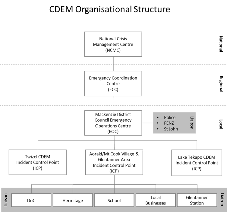
6.3 Support Agencies
Appendix B sets out the organisational structure and
shows the interlinking of organisations, hence the necessity for planning and
coordination with these agencies/key partners.
6.3.1 Police
There is no Police Officer stationed at the
Aoraki/Mount Cook Village. Staff based at Twizel and Tekapo provide the
necessary police function in the area and are involved regularly with many
search and rescue operations that occur within the National Park. Police are
able to access their radio system from the Village. With a large number of
climbers in the Park at any one time it is the Police responsibility for their
safety. The majority of these climbers are aware of the conditions in these
Parks and take the necessary precautions however accidents do happen, hence
SAR.
6.3.2 Fire and Emergency New Zealand
(FENZ)
The Aoraki/ Mt Cook Rural Fire Force is based in the
Village. This service is manned by volunteers and operates out of the DOC
emergency services facilities. Their area of responsibility includes the
village to Twin Stream (including Glentanner). Callout is via the 111 system
with additional backup provided by volunteer fire brigade units at Twizel,
Tekapo and further afield if necessary.
6.3.3 St John Ambulance
An ambulance is based in the Village and operates out
of the DOC emergency services facilities. Call out is via the 111 system. Backup is provided by
ambulances at Twizel and further afield if necessary. Air ambulances may be
available in addition to road resources.
6.3.4 Department of Conservation (DOC)
DOC has the mandate with regard to the operation of
the National Park and virtually every aspect of the operational and commercial
activities which occur within the area boundaries. DOC is primarily responsible
for all safety matters including the notification to the public of emergency
related events which could impact on the Village and visitors to the Park. DOC
operate two distinct duty officer roles, being the village duty officer and the
mountain duty officer, each of whom will operate in regard to their mandated
DOC roles.
Should a water supply, wastewater or other event
within the Village potentially impact on the community, the Community
Coordinator and MDC duty CDEM officer should be notified.
DOC maintains an excellent radio network and has links
back to the MDC via a dedicated CDEM VHF system. A high level of co-operation
exists between DOC and the MDC.
6.3.5 Ministry of Social Development
Should support of the Ministry of Social Development
(MSD) be required this will be co-ordinated by the EOC in conjunction with the
Welfare Co-ordinator.
7 RESPONSE
7.1 Warnings
7.1.1 General
Most events, excluding earthquakes will allow for the
timely issuing of a warning.
7.1.2 Inward
Weather warnings are issued by the Met Service. These
are received by the DOC village duty officer and acted on by their Standard
Operating Procedures if they are of concern the Community Co-ordinator will be
notified. The MDC duty CDEM officer may also contact the Community Co-ordinator
to discuss concerns with the weather warnings or vice
versa.
Avalanche forecasts are available for
Aoraki/Mount Cook on avalanche.net.nz/ It is the responsibly of the DOC
mountain duty officer to monitor the avalanche risk forecast within this area.
When deemed appropriate, the mountain duty officer will advise the Community
Controller of the forecasts.
Black Birch Stream high water warning
system is a sensor attached to the Black Birch Stream Bridge with a landline to
Park Headquarters. The alarm is raised by setting off an e-text to the DOC duty
officer. From previous experience with this system, the trigger point is
approximately 200mm of rain in the previous 24 hour period. This would be
considered an early trigger point. The duty officer is to inspect all streams
and inform the Community Coordinator of the need to take action. This data
should be recorded by the duty officer and collated and sent to MDC duty CDEM officer annually for future risk planning.
Environment Canterbury Regional Council (ECAN)
maintains an extensive telemetry network throughout the Canterbury region which
is monitored by staff at either their Christchurch or Timaru offices. Sites
operated by NIWA and which provide information for Meridian are located at Pan
Ridge, Eade Hut, Hooker and in the Village. ECAN have a site which monitors the
Hooker catchment and are also able to access the NIWA sites. For online
information refer to https://www.ecan.govt.nz/data/rainfall-data/. The staff at ECAN Timaru are very
experienced in carrying out and supervising emergency works in rivers
throughout the district and their advice should always be considered.
Informal network: There are a number of
long-term residents with excellent weather monitoring ability. When possible,
the Community Coordinator can make contact with them.
7.1.3 Outward
Whenever a warning is received from the Met Service or
any other agency which could impact on the safety of the public in the area,
the DOC duty officer and any other organisation involved must ensure that the
Community Co-ordinator is informed. Depending on the warning,
consultation should take place to determine the actions which should be taken.
Early consultation by the Community Coordinator with
other agencies within the area is recommended as with the MDC CDEM Duty Officer
in Fairlie.
7.2 Alpine Huts
After any major event (Earthquake, Gale Force Winds
etc.) within the Aoraki/Mount Cook village, National Park or Glentanner area
where there is potential damage to infrastructure, an over flight of all Alpine
Huts within the area should be considered as part of any reconnaissance flights
to check for damage and the welfare of any occupants. This will be actioned by
the DOC operations manager on a case by case basis, this will be notified to
the Community Coordinator when actioned and on receipt of any information from
said flights.
7.3 Walking Tracks
Aoraki/Mount Cook National Park includes a number of
walkways ranging from easy grade to alpine passes. It is recognised that, a
number of visitors use these tracks. In the event of an incident, it is
anticipated that people will self-evacuate to the carparks/village where usual
procedures can occur. Serious events may require further action. This will be
directed by the Community Coordinator in conjunction with DOC operations
manager.
7.4 Alps 2 Ocean
The Community Coordinator should consider users of the
Alps 2 Ocean cycle trail. This should include those travelling across Lake
Pukaki but exclude trail users on the eastern side of Lake Pukaki.
7.5 White Horse Hill
Campground
The Whitehorse camping ground should be inspected as
soon as possible and the situation reported back to the Community Co-ordinator.
This will be the responsibility of DOC staff.
7.6 Glentanner Holiday
Park
The Glentanner Holiday Park and Park Centre
accommodate overnight and day guests. Management of the Park will oversee the
area, and communicate with the Community Coordinator or welfare coordinator as
required. The communication will be two-way sharing of updates and warnings for
the respective areas.
7.7 Evacuation
Procedures
Evacuation of the Village and/or Glentanner area will
be dependent upon the potential threat and the availability of a safe location,
alternative accommodation, the time and the weather. The Local Controller will
consult with the Community Coordinator and key personnel in making any decision
regarding evacuation.
If an evacuation (or partial evacuation) is ordered by
the Local Controller, or any Constable this shall be undertaken in accordance
with Section 86 of the Act.
Security of the evacuated area will be the
responsibility of the New Zealand Police.
NB Police may or may not be located in the Village.
During school hours priority should be given to the
school to assist them to activate their evacuation plan.
Transport options for an evacuation process could
include:
1. Coach
2. 4WD
Utilities
3. Private
Vehicles
If the decision is made to evacuate the entire village
externally, the Local Controller, in conjunction with the Community
Coordinator, will plan the evacuation in relation to the departure point and
the arrival point. e.g. Helicopter to Glentanner and then plane to Pukaki /
Lake Tekapo / Timaru or further afield.
The Welfare coordinator is to ensure that all evacuees
complete a registration card and accurate records are kept of all travel
movements including passenger manifests. Glentanner Park will record the
details of all personnel in their care. These will be passed onto the Welfare
Manager in the EOC as soon as possible.
If needed, additional welfare support could be
provided. This support will be coordinated through the Local Controller and the
Welfare Manager located at the EOC.
The Community Coordinator shall be kept informed of
any situation where people may need to be relocated or evacuated and of any
financial implications. If communication exists with the EOC, the Local
Controller will approve any evacuations or expenditure before they commence.
7.8 Welfare
The Welfare Co-ordinator: Pip Walter Deputy:
Currently unallocated
Depending on the emergency event and whether there is
a need to evacuate people, the welfare requirements may include:
1. Conducting
a needs assessment for all personnel if required or requested by the Local
Controller.
2. The
provision of emergency catering for evacuees and emergency workers;
3. The
coordination and provision of temporary accommodation for evacuees and workers;
4. The
supply and distribution of clothing;
5. Coordinating
personal services (including counselling, first aid and routine medical
requirements with local doctors, pharmacies and St John), financial assistance
and translation services;
6. Registration
of evacuees and personnel both entering and leaving the area.
8 RECOVERY
Recovery should start while the response stage is in
progress, and carry on after the Local Controller makes a formal report to MDC
when the response stage is completed and the emergency is terminated.
The transfer from response to recovery will be
actioned with reports from the Local Controller
outlining:
1. The
response action plan;
2. The
type and status of all assigned resources;
3. Any
action taken regarding expenditure;
4. A
summary of damage at the time of transition.
The Local Recovery Manager, on being appointed, will
set-up a recovery management team in consultation with DOC. This team will
identify priorities and actions. This may include the notification of a Local
Transition Period (section 94B CDEM 2002).
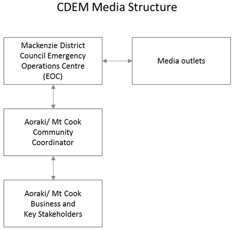
9 MEDIA LIAISON
In the event that an emergency is declared, all media
contact should be made through the EOC.
Once the emergency has been terminated and/or in the
event of a village evacuation but not an emergency, all information (including
operating status, damage or loss) pertaining to current agencies operating out
of Aoraki/Mount Cook Village and Glentanner area must be confirmed with senior
management from the relevant agency or organisation prior to release to the
media.
WARNING: LIAISON BETWEEN THE LOCAL CONTROLLER,
COMMUNITY CO-ORDINATOR AND AORAKI/MT COOK AGENCIES REGARDING MEDIA RELEASE IS
CRUCIAL.
10 FINANCIAL
10.1 Expenditure during declared events.
During an emergency, local authorities are responsible
for meeting all the costs associated with their own CDEM personnel, facilities
and resources.
Emergency services and other agencies, including
government agencies, are responsible for meeting the costs of their personnel,
facilities and specialist advice when carrying out their CDEM functions, except
where there is agreement in advance that costs may be reimbursed[4].
The above does not absolve tour operators,
accommodation venues, and any other organisation involved in the area from
accepting liability for people within their care and on their premises.
In the event of an emergency affecting people at the
Aoraki/Mount Cook Village and Glentanner area, all operators shall have
contingency plans detailing the steps which they will take to provide for the
safety of their clients. This may include looking after people on their
premises or evacuation to another location.
Every effort shall be made to ensure that rates
charged for additional accommodation and meals are set at a realistic level
during an emergency.
Records to assist with the reconciliation of accounts
must be maintained for all actions taken. These records shall be passed
to the MDC at the end of the emergency to assist with the quick settlement of
accounts and queries.
Any reimbursement sought is to be submitted in terms
of the Group Plan 2014 Section 2.7.3.
A clear record of who authorises any expenditure and its purpose is to be
maintained and authorised by the Local Controller.
11 ROAD CLOSURE
An established system is in place to deal with road
closures and the reporting of conditions.
11.1 State Highway
State Highway 80 from Pukaki to Aoraki/Mount Cook
Village provides the only road access into the area. Conditions on these roads
can change rapidly due to flooding, snow, ice, and wind. This State Highway is
maintained by NZTA.
It should be noted that road closures of the State
Highway may impact the roading section between Glentanner and Aoraki/Mt Cook
Village and/or the road to Glentanner from the intersection of SH8 and SH80.
If information is on State Highways is required, or
there is a necessity for road closures or media publicity, contact: DOWNER
NZ Ltd (Timaru) Phone 03 687 2751
11.2 Village Roads
The roads around the village including Hooker Valley
Rd and Tasman Valley Rd are administered and maintained by DOC.
Responsibilities of DOC include snow clearing and closing of roads within this
area.
12 APPENDIX A – DELEGATIONS
Delegation of Powers Matrix
Reference:
Civil Defence Emergency Management Act 2002
|
Emergency Powers
|
Delegated to
|
|
s85(a)
– Carryout works, clearing roads and other public places, removing or
disposing of, or securing of, or otherwise making safe, dangerous
structures.
|
Local Controller
|
|
|
|
|
s85(b)
– Provide for the rescue of endangered persons and their removal to
areas of safety.
|
Local Controller
|
|
|
|
|
s85(c)
– Set up first aid posts, and provide for first aid to be given to
casualties and for their movement to hospitals, other places of treatment, or
areas of safety.
|
Local Controller
|
|
|
|
|
s85(d)
– Provide for the relief of distress, including emergency food,
clothing, and shelter.
|
Local Controller
|
|
|
|
|
s85(e)
– Provide for the conservation and supply of food, fuel and other
essential supplies.
|
Local Controller
|
|
|
|
|
s85(f)
– Prohibit or regulate land, air, and water traffic within the area or
district to the extent necessary to conduct civil defence emergency
management.
|
Local Controller
|
|
|
|
|
s85(g)
– Undertake emergency measures for the disposal of dead persons or
animals if it is satisfied that the measures are urgently necessary in the
interests of public health.
|
Local Controller
|
|
|
|
|
s85(h)
– Disseminate information and advice to the public.
|
Local Controller
|
|
|
|
|
s85(i)
– Enter into arrangements, including employment arrangements, with any
person for the purpose of carrying out civil defence emergency management as
may be agreed.
|
Local Controller
|
|
|
|
|
s85(j)
– Provide equipment, accommodation, and facilities for the exercise of
any of the powers conferred by s85.
|
Local Controller
|
|
|
|
|
s86
– Evacuation of persons or vehicles from any area within the emergency
for the preservation of human life. This also includes excluding persons and
vehicles for areas within the emergency.
|
Local Controller
|
|
|
|
|
s87 -
Entry into any building or on any land, without warrant, by any person in the
course of implementing an emergency plan or if otherwise considered by the
local authority to be necessary to prevent, respond to or alleviate the
effects of an emergency.
|
Local Controller
|
|
|
|
|
s88
– Closure of roads or public places in order to limit or prevent the
extent of the emergency.
|
Local Controller
|
|
|
|
|
s89
– Remove aircraft, vessels, vehicles etc in order to limit or prevent
the extent of the emergency.
|
Local Controller
|
|
|
|
|
s90
– Requisitioning powers of equipment, resources, land or property may
be used if needed for the preservation of human life.
|
Local Controller
|
|
|
|
|
s91
– Power to give direction to stop and activity contributing to the
emergency or to limit or prevent the extent of the emergency.
|
Local Controller
|
|
|
|
|
s92
– Power to examine, mark, seize, sample, secure, disinfect, or destroy
and property, animal or other thing in order to limit or prevent the extent
of the emergency.
|
Local Controller
|
|
|
|
|
s93
– Enter into contracts in order to limit or prevent the extent of the
emergency.
|
Local Controller
|
|
|
|
NOTE: Any person delegated to carry out any of these
powers must be able to produce identification and an explanation of the
authority under which they are acting.
These powers are deemed to be delegated to the
community coordinator when all attempts of communication to the EOC fail.
A record will be kept of when powers were used and by
who.
13 APPENDIX B – CDEM
ORGANISATIONAL STRUCTURE
14 APPENDIX C – PRE-DECLARATION
CHECK LIST
To be completed by Response Manager –
MDC Date:
Time:
If no communication
can be established with the MDC EOC, it is expected that the Community
Co-ordinator
will complete this process and note why the powers of the Controller have been
assumed.
|
|
YES
|
NO
|
|
Is there a situation that causes or may
cause loss of life or injury or distress or in any way endangers or may
endanger the safety of the public or property?
|
|
|
|
Is the situation such that it cannot be
dealt with by Emergency Services or other organisations at Aoraki/Mount Cook
& Glentanner?
|
|
|
Views of:
|
ORGANISATION
|
VIEWS
FROM
|
NAME
|
TIME
|
COMMENT
|
|
Y
|
N
|
|
POLICE
|
|
|
|
|
|
|
FENZ
|
|
|
|
|
|
|
ST JOHN
|
|
|
|
|
|
|
DOC
|
|
|
|
|
|
|
GLENTANNER
|
|
|
|
|
|
|
HERMITAGE
|
|
|
|
|
|
|
OTHER (specify)
|
|
|
|
|
|
|
|
|
|
|
|
|
|
|
|
|
|
|
|
|
|
YES
|
NO
|
|
Will a declaration enable improved
response?
|
|
|
|
Is the CDEM organisation ready to
exercise control?
|
|
|
|
Does the Community Coordinator recommend
a declaration?
|
|
|
|
Has the Controller been briefed by the
Community Controller?
|
|
|
If a declaration is made, it must be made by the appropriate
person as outlined in Section 6.7.2 of the Canterbury CDEM Group Plan (June
2014).
Controllers Decision:
|
|
YES
|
NO
|
|
Controller’s decision to declare?
|
|
|
|
Comment:
|
Controllers Name: ___________________Signature: __ _____
____ Time/Date: ____________
If declaration is recommended the appropriate
declaration form must be filled out in the EOC and signed by the authorised
person (Mayor) prior to any actions being taken.
15 APPENDIX D – CONTACT LIST
(confidential – details
withheld)
16 APPENDIX
E – COMMUNICATION PLAN
Mackenzie
Emergency Operations Centre
In the event of the EOC being activated task related
cell phones maybe utilised and these phone numbers will be circulated at that
time, as they will be monitored from the time of activation.
|
|
Voice number
|
Fax number
|
|
B-GAN
|
Withheld – for CDEM
purposes only
|
Withheld – for CDEM
purposes only
|
Radio
Communication
Mackenzie District Council also maintain an extensive
VHF radio communications network operating on ES 2 channel Tx 141.02500 Rx
138.025
The following is a table with the location of the
radios and call signs of those sets.
|
RADIO LOCATION
|
CALLSIGN
|
|
Aoraki/ Mt Cook
Emergency Services building
|
Mount Cook civil
defence
|
|
Hermitage
reception
|
Mount Cook
Hermitage
|
|
Glentanner Park
|
Glentanner Park
|
|
Meridian Twizel
|
Meridian
|
|
Mackenzie
District Council - Fairlie
|
Mackenzie EOC
|
|
Mackenzie
District Council - Twizel
|
Twizel Council
|
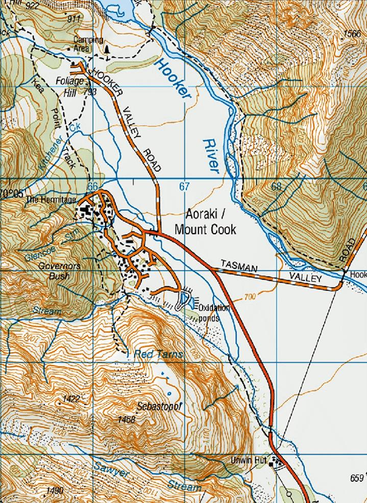
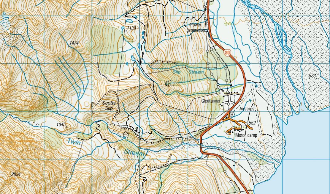
17 APPENDIX F – TOPOGRAPHIC MAP OF
AORAKI/MOUNT COOK